 |
| Cape Breton Waterfront Real Estate Listing |


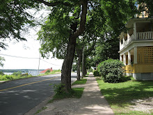
Side view
Monday, April 4, 2011
Monday, March 7, 2011
Cape Breton Bike Fest
http://www.capebretonbikefest.com/rides.php
The following scenic trails and roads are a must do at your leisure.
We do have escorted rides that will have parts of these trails and roads included in the route.: Cabot Trail, Marconi Trail, Ceilidh Trail, Bras d’Or Lakes Scenic Drive, The Miners Museum, Iona, Louisbourg, and Baddeck.
Click the links below to find more info on these sites. For the full list and descriptions of the escorted rides,please look under the schedule tab.
Cabot Trail
Marconi Trail
Fleur De Lis Trail
Ceilidh Trail
Bras d’Or Lakes Scenic Drive
Highland Village Museum
Fortress of Louisbourg
Miner’s Museum
Baddeck
The Cabot Trail Relay Race
The Cabot Trail Relay Race is a 185 mile/276.33 km, 17 stage relay race through some of the most beautiful scenery in the world... beginning in Baddeck, Cape Breton, over steep mountains in the Cape Breton Highlands National Park, through many small communities around the famous Cabot Trail, to the gently rolling Margaree Valley.
History
In 1988 the idea of holding a relay race around the Cabot Trail was created, and 6 teams of 17 runners per team tested out the feasibility of the idea. Thus was created one of the largest and most popular running events in eastern Canada. Now 60 teams from across Canada and the US compete in an event marked by team spirit and camaraderie. More than 1000 runners travel the Cabot Trail which offers some of the most challenging and spectacular terrain in North America.
The race takes place at the end of May in the shoulder tourist season and has done much to boost the economy of the small area, and encourages community groups to host fund raising events at the time of the relay. The race makes a contribution to the 3 hospitals along the race route, and in 1995 was instrumental in setting up bursaries for each of the four high schools on the Cabot Trail.
The race is organized by a dedicated group of volunteers who work hard to ensure that this event is truly memorable for all runners from recreational to highly competitive. In accordance with our mission statement we invite you to be a part of our truly unique event in the name of friendship and safety.
The Cabot Trail Relay Race Legs
| Start on the Cabot Trail, at the Gaelic College monument, 1.1 km from Exit 11 off #105 Highway,and finish after crossing the North River Bridge, at the church on the left. This is a gently rolling leg with one long, moderate hill rising from 0 to 50m. Great scenery at this time of day. | ||||
| This long easy rolling leg finishes at the Clucking Hen Cafe on the right along the North Shore and passes through a quiet, remote river valley with a maximum elevation of 60 m. | ||||
| This leg finishes at Wreck Cove General Store on the left. A rolling leg with a few short hills. | ||||
| The first 9 km are continuous easy ups & downs but the best is yet to come. You must now climb Cape Smokey which is 2.1 km of extremely steep grade. For distraction there is a wonderful ocean view and you may even spot a whale! Relax for the steep downhill on the way to the finish. A couple more hills will take you to the finish at Cape Smokey Ski Lodge on the left. | ||||
| A long moderate up to Ingonish Beach, where you enter Cape Breton Highlands National Park, then go gently rolling downhill through the village of Ingonish, with its local traffic and spectators. This leg finishes at the Marianne Falls Warren Lake entrance past the Broad Cove campsite on the left. | ||||
| The scenery on this seacoast run will captivate you despite a couple of long challenging hills. This leg climbs to the finish at Cabot High School on the right. Elevation 90m. Be prepared for strong coastal breezes. | ||||
| A rolling leg but the first 8 km climbs steadily 90m and then falls quickly to finish 0.2 km past the Dingwall garage. FINISHING ON THE RIGHT | ||||
| An easier leg with a gorgeous view of the Sunrise Valley on the right. There is a slow steady 3 km climb in the beginning. After this you are rewarded by a flat stretch which permits you to soak in the beauty of your surroundings as you run into the finish line just up the road to the old Park Warden Station before you get to the North Aspy River. | ||||
| Time to put on the reflective vest! This leg makes Smokey look like a piece of cake. North Mountain, in the national park, climbs 385m & reaches the top at 6.2 km then falls back to sea level. The route then levels off to finish at Mountain View Motel & Restaurant on the right at Pleasant Bay. Night will have fallen completely. | ||||
| This leg is for people who like running up hills. The first 3.1 km are just to warm up & get you to the base of MacKenzie Mountain (otherwise known as The Snake) and back in the national park. The route then climbs 385m snaking back & forth up the side of the mountain for 6.2 km. It then levels off for the rest of the leg & finishes at the parking lot on the right at Benjie’s Lake. | ||||
| This leg is for the runner who likes to run downhill. The first 5.8 km climbs steadily to an elevation of 460m. Relax and coast down the next stretch to sea level but be on the alert for the Northern Lights. But beware, there are two very steep hills before the finish. | ||||
| Easy rolling leg with a nice view of the Gulf on the right (in the daylight!). Descends from 60m at the look-off to sea level & will be your second brush with civilization as you leave the national park and go through the town of Cheticamp with its Saturday night traffic. This leg ends at the parking lot on the right across from Chaisson Brothers’ Garage. | ||||
| Easy rolling leg through Acadian farms & seacoast to finish at Joe’s Scarecrow & Diner. A quiet peaceful leg for the night owl on your team; no street lights out here. Rises to a maximum elevation of 30m. | ||||
| This long leg begins near dawn and is a 7.9 km level coastal run to Margaree Harbour. The leg heads inland & starts to rise gradually to a maximum elevation of 10m to finish at the Tourist Bureau on the left across from Margaree Lodge. | ||||
| Now that daylight has arrived enjoy the scenic Margaree Valley as you roll along this fairly easy leg which finishes at the Lakes Cafe on the left. Maximum elevation on this leg is 30m. | ||||
| This is the flattest leg in the race. It finishes at the gravel pits, just beyond the churches in Middle River on the left. It rises from approximately 30m to a maximum elevation of 50m | ||||
| This leg starts at the two Churches in Middle River gives you a nice and easy 2km before you rise 3.5 km up Hunter’s Mountain on a fairly steep grade to an elevation of 150m. It then falls quickly and turns sharp left to the Swamp Rd, which is 5 km of high grade gravel road. First there is some uphill to the Baddeck Bridge, then downhill to the Court House in Baddeck for the finish. |
Subscribe to:
Posts (Atom)